Close Menu
TechCentralTechCentral

    Subscribe to the newsletter

    Get the best South African technology news and analysis delivered to your e-mail inbox every morning.

    Facebook X (Twitter) YouTube LinkedIn
    WhatsApp Facebook X (Twitter) LinkedIn YouTube
    TechCentralTechCentral
    • News
      South Africa's AI policy is a bureaucrat's dream - Solly Malatsi

      South Africa’s draft AI policy is a bureaucrat’s dream

      10 April 2026
      Big Tech is going nuclear

      Big Tech is going nuclear

      10 April 2026
      5G expected to reshape South Africa's wireless broadband market

      5G expected to reshape South Africa’s wireless broadband market

      10 April 2026
      Warning that South Africa's digital competitiveness is in retreat

      Warning that South Africa’s digital competitiveness is in retreat

      10 April 2026
      South Africa's biggest banks are lining up behind Optasia - Salvador Anglada

      South Africa’s biggest banks are lining up behind Optasia

      10 April 2026
    • World
      Anthropic mulls building its own AI chips

      Anthropic mulls building its own AI chips

      10 April 2026
      DeepSeek V4 to run on Huawei silicon as China builds its own AI stack

      DeepSeek V4 to run on Huawei silicon as China builds its own AI stack

      4 April 2026
      Amazon in talks to buy satellite operator Globalstar

      Amazon in talks to buy satellite operator Globalstar

      2 April 2026

      Apple plans to open Siri to rival AI services

      27 March 2026
      It's official: ads are coming to ChatGPT

      It’s official: ads are coming to ChatGPT

      23 March 2026
    • In-depth
      Africa switches on as Europe dims the lights

      Africa switches on as Europe dims the lights

      9 April 2026
      The biggest untapped EV market on Earth is hiding in plain sight

      The biggest untapped EV market on Earth is hiding in plain sight

      1 April 2026
      The R18-billion tech giant hiding in plain sight - Jens Montanana

      The R16-billion tech giant hiding in plain sight

      26 March 2026
      The last generation of coders

      The last generation of coders

      18 February 2026
      Sentech is in dire straits

      Sentech is in dire straits

      10 February 2026
    • TCS
      TCS+ | Vodacom Business moves to crack the SME tech gap - Andrew Fulton, Sannesh Beharie

      TCS+ | Vodacom Business moves to crack the SME tech gap

      7 April 2026
      TCS | MTN's Divysh Joshi on the strategy behind Pi - Divyesh Joshi

      TCS | MTN’s Divyesh Joshi on the strategy behind Pi

      1 April 2026
      Anoosh Rooplal

      TCS | Anoosh Rooplal on the Post Office’s last stand

      27 March 2026
      Meet the CIO | HealthBridge CTO Anton Fatti on the future of digital health

      Meet the CIO | Healthbridge CTO Anton Fatti on the future of digital health

      23 March 2026
      TCS+ | Arctic Wolf unpacks the evolving threat landscape for SA businesses - Clare Loveridge and Jason Oehley

      TCS+ | Arctic Wolf unpacks the evolving threat landscape for SA businesses

      19 March 2026
    • Opinion
      The conflict of interest at the heart of PayShap's slow adoption - Cheslyn Jacobs

      The conflict of interest at the heart of PayShap’s slow adoption

      26 March 2026
      South Africa's energy future hinges on getting wheeling right - Aishah Gire

      South Africa’s energy future hinges on getting wheeling right

      10 March 2026
      Hold the doom: the case for a South African comeback - Duncan McLeod

      Apple just dropped a bomb on the Windows world

      5 March 2026
      R230-million in the bag for Endeavor's third Harvest Fund - Alison Collier

      VC’s centre of gravity is shifting – and South Africa is in the frame

      3 March 2026
      Hold the doom: the case for a South African comeback - Duncan McLeod

      Hold the doom: the case for a South African comeback

      26 February 2026
    • Company Hubs
      • 1Stream
      • Africa Data Centres
      • AfriGIS
      • Altron Digital Business
      • Altron Document Solutions
      • Altron Group
      • Arctic Wolf
      • Ascent Technology
      • AvertITD
      • BBD
      • Braintree
      • CallMiner
      • CambriLearn
      • CYBER1 Solutions
      • Digicloud Africa
      • Digimune
      • Domains.co.za
      • ESET
      • Euphoria Telecom
      • HOSTAFRICA
      • Incredible Business
      • iONLINE
      • IQbusiness
      • Iris Network Systems
      • Kaspersky
      • LSD Open
      • Mitel
      • NEC XON
      • Netstar
      • Network Platforms
      • Next DLP
      • Ovations
      • Paracon
      • Paratus
      • Q-KON
      • SevenC
      • SkyWire
      • Solid8 Technologies
      • Telit Cinterion
      • Telviva
      • Tenable
      • Vertiv
      • Videri Digital
      • Vodacom Business
      • Wipro
      • Workday
      • XLink
    • Sections
      • AI and machine learning
      • Banking
      • Broadcasting and Media
      • Cloud services
      • Contact centres and CX
      • Cryptocurrencies
      • Education and skills
      • Electronics and hardware
      • Energy and sustainability
      • Enterprise software
      • Financial services
      • HealthTech
      • Information security
      • Internet and connectivity
      • Internet of Things
      • Investment
      • IT services
      • Lifestyle
      • Motoring
      • Policy and regulation
      • Public sector
      • Retail and e-commerce
      • Satellite communications
      • Science
      • SMEs and start-ups
      • Social media
      • Talent and leadership
      • Telecoms
    • Events
    • Advertise
    TechCentralTechCentral
    Home » Sections » Enterprise software » How geospatial insights can transform service delivery planning and analysis in South Africa

    How geospatial insights can transform service delivery planning and analysis in South Africa

    Promoted | Geospatial science can empower municipalities with the data they need to close the gaps in service delivery.
    By AfriGIS3 September 2025
    Twitter LinkedIn Facebook WhatsApp Email Telegram Copy Link
    News Alerts
    WhatsApp

    How geospatial insights can transform service delivery planning and analysis in South AfricaService delivery remains one of South Africa’s most critical challenges, especially from the perspective of local municipalities. Whether it’s waste management, water supply or housing, the ability to effectively serve citizens relies heavily on accurate, up-to-date data.

    However, many municipalities still rely on outdated or incomplete information, which leads to poor planning, uncollected waste and crucial gaps in service provision.

    Worse still, this often results in thousands of households missing from official systems, making it difficult to plan and deliver essential services efficiently.

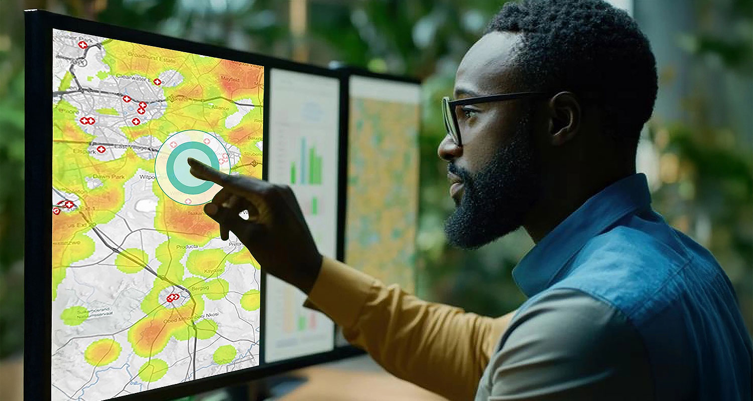
    Geospatial science can help tackle these issues, empowering municipalities with the data they need to make informed decisions, ensure comprehensive coverage and close the gaps in service delivery. Here’s how.

    The challenge: outdated data and reactive planning

    A recurring challenge for municipalities is the inaccuracy of their data, particularly when it comes to service delivery. Take waste management, for example. During audit seasons, auditors often ask municipalities to report on the number of households they are servicing and the efficiency of their waste collection efforts. This is when discrepancies become evident. Often, municipalities discover that their routes are picking up waste in areas that aren’t even registered within their official systems—these areas were developed informally, without proper municipal registration.

    In one case, a municipality struggled to identify a large area of newly developed sectional schemes where people had built properties without the required permits. While waste collection continued in these areas, the municipality was unaware that these areas had not been officially captured in their service systems. The waste trucks were continuing to pick up refuse as part of their regular route, but the area was unregistered, and there was no record of who should be billed for the service. In one case, a municipality was unknowingly providing waste collection services to over 22 000 households in newly developed sectional schemes that were not registered in their systems. Despite these areas being serviced as part of regular waste collection routes, the municipality had no official record of these properties. Serious concerns are flagged such as if these households are being billed correctly? Were infrastructure and service delivery plans accounting for them?

    This situation raises critical questions: Why are municipalities collecting waste in unregistered areas? How can they ensure proper registration, infrastructure planning and service delivery to these communities?

    The solution: geospatial insights for proactive service delivery

    Using geospatial science, municipalities can move beyond this reactive approach and embrace proactive service delivery. Through our AfriGIS’s platform, we help municipalities gain a comprehensive understanding of both formal and informal developments. By integrating various data sets—such as cadastral data, land use, property registration and even informal settlement growth patterns—we provide a holistic view of where services are being delivered and where gaps still exist.

    For instance, using real-time geospatial data, we can identify informal settlements that are expanding rapidly but have not been properly captured in official records. We can help municipalities ensure that all households – formal and informal – are accounted for in their systems, and that services are being delivered where they are needed most.

    Real-world impact: waste management and infrastructure planning

    One of the biggest challenges in municipalities, especially in South Africa, is understanding where services like waste management, water and electricity are needed. Without accurate geospatial data, it’s difficult to identify service gaps, leading to an inefficient use of resources.

    A municipality, for instance, may be spending unnecessary resources servicing areas that were not properly registered, as we saw with the waste management issue. We help prevent this by helping to accurately identify high-density areas, track population growth and spot new developments in real time, so resources can be deployed efficiently. For example, a municipality might waste valuable resources servicing areas where billing is uncertain – as we saw with the waste management issue.

    AfriGIS’s solution helps optimise resource allocation by accurately identifying high-density zones, monitoring population growth and detecting new developments in real time. This ensures efficient deployment of services while reducing unnecessary costs.

    Additionally, when municipalities are planning for infrastructure – such as RDP housing projects – they need to ensure that land is suitable for development. If land has dolomite or flood risks, in particular, that can significantly affect both the viability of a development and its future residents. AfriGIS provides data on land use, risk factors and environmental hazards, allowing municipalities to make informed decisions about where to build and what type of services will be required.

    Reducing national security risks and promoting better infrastructure development

    An often-overlooked aspect of service delivery is the lack of transparency regarding infrastructure. In some areas, unofficial access points have been created, such as people tapping into water pipes or electricity lines without proper registration, sometimes even compromising national security.

    Through AfriGIS’s geospatial analysis, municipalities can clearly visualise the network of existing infrastructure and identify areas where resources are being diverted illegally. AfriGIS’s platform allows us to highlight key risks, like unregistered water connections, which not only prevent municipalities from billing customers, but also pose national security risks.

    For instance, knowing the location of power lines, piping systems and other critical infrastructure can help municipalities plan more effectively. This data also helps ensure that any new development—be it informal settlements or formal housing—is built with an understanding of infrastructure capabilities, reducing the risk of issues like illegal connections or infrastructure overload.

    Planning for the future: aiding proactive responses to growth

    Service delivery cannot be simply about responding to current needs; it must also anticipate future growth. Take weather patterns. During rainy seasons, municipalities can face serious flooding issues in certain areas that were not previously considered flood prone. With the help of AfriGIS’s Flood Hazard Index, municipalities can forecast flood risks and ensure they’re building infrastructure in areas that won’t compromise the safety and well-being of residents.

    Similarly, understanding the road networks, transportation links and proximity to points of interest like schools and healthcare facilities enables municipalities to plan future service delivery with a much clearer view of how residents interact with their environment.

    A strong example of this was AfrGIS’s work in Swaziland where we helped local health authorities plan better immunisation distribution by mapping out the road networks, identifying bottlenecks and optimising the placement of mobile clinics to reduce travel time for rural residents.

    Moving from reactive to proactive service delivery

    The key takeaway here is that accurate, real-time geospatial data is vital for effective service delivery. Without this, municipalities are simply guessing where resources are most needed, often at the expense of efficiency and cost-effectiveness. AfriGIS helps municipalities transition from a reactive to a proactive service delivery model, ensuring they can anticipate and address gaps in service provision before they become major issues.

    By incorporating geospatial analysis into their systems, municipalities gain the ability to track real-time growth patterns, assess risks and make smarter decisions that improve both the quality and reach of their services. The result is a more efficient, responsive and sustainable service delivery framework, built on trusted data and forward-thinking planning.

    AfriGIS is helping municipalities plan better, serve more effectively and ultimately build communities that are well-equipped for future growth.

    • The author, Vuyo Mazabane, is senior account manager at AfriGIS
    • Read more articles by AfriGIS on TechCentral
    • This promoted content was paid for by the party concerned

    Don’t miss:

    AfriGIS recognised as a core contributor to GeoServer

    Follow TechCentral on Google News Add TechCentral as your preferred source on Google


    AfriGIS Vuyo Mazabane
    WhatsApp YouTube
    Share. Facebook Twitter LinkedIn WhatsApp Telegram Email Copy Link
    Previous ArticleWorkday’s Evisort brings Popia compliance and speed to SA contracts
    Next Article Paratus launches first private mobile network in Namibia

    Related Posts

    How AfriGIS is helping retailers win the delivery race

    How AfriGIS is helping retailers win the delivery race

    4 December 2025
    Structured addresses, smarter systems: GIS empowers ISO 20022 compliance

    Structured addresses, smarter systems: GIS empowers ISO 20022 compliance

    18 November 2025
    From click to doorstep - optimising last-mile delivery with GIS - AfriGIS

    Why accurate addresses are the new currency in South African e-commerce

    22 October 2025
    Add A Comment

    Comments are closed.

    Company News
    Vertiv AI Innovation Roadshow returns to Africa as virtual event

    Vertiv AI Innovation Roadshow returns to Africa as virtual event

    10 April 2026
    What South African parents look for in an online school - CambriLearn

    What South African parents look for in an online school

    9 April 2026
    Modernising legacy systems - without the downtime - BBD Software

    Modernising legacy systems – without the downtime

    9 April 2026
    Opinion
    The conflict of interest at the heart of PayShap's slow adoption - Cheslyn Jacobs

    The conflict of interest at the heart of PayShap’s slow adoption

    26 March 2026
    South Africa's energy future hinges on getting wheeling right - Aishah Gire

    South Africa’s energy future hinges on getting wheeling right

    10 March 2026
    Hold the doom: the case for a South African comeback - Duncan McLeod

    Apple just dropped a bomb on the Windows world

    5 March 2026

    Subscribe to Updates

    Get the best South African technology news and analysis delivered to your e-mail inbox every morning.

    Latest Posts
    South Africa's AI policy is a bureaucrat's dream - Solly Malatsi

    South Africa’s draft AI policy is a bureaucrat’s dream

    10 April 2026
    Big Tech is going nuclear

    Big Tech is going nuclear

    10 April 2026
    5G expected to reshape South Africa's wireless broadband market

    5G expected to reshape South Africa’s wireless broadband market

    10 April 2026
    Warning that South Africa's digital competitiveness is in retreat

    Warning that South Africa’s digital competitiveness is in retreat

    10 April 2026
    © 2009 - 2026 NewsCentral Media
    • Cookie policy (ZA)
    • TechCentral – privacy and Popia

    Type above and press Enter to search. Press Esc to cancel.

    Manage consent

    TechCentral uses cookies to enhance its offerings. Consenting to these technologies allows us to serve you better. Not consenting or withdrawing consent may adversely affect certain features and functions of the website.

    Functional Always active
    The technical storage or access is strictly necessary for the legitimate purpose of enabling the use of a specific service explicitly requested by the subscriber or user, or for the sole purpose of carrying out the transmission of a communication over an electronic communications network.
    Preferences
    The technical storage or access is necessary for the legitimate purpose of storing preferences that are not requested by the subscriber or user.
    Statistics
    The technical storage or access that is used exclusively for statistical purposes. The technical storage or access that is used exclusively for anonymous statistical purposes. Without a subpoena, voluntary compliance on the part of your Internet Service Provider, or additional records from a third party, information stored or retrieved for this purpose alone cannot usually be used to identify you.
    Marketing
    The technical storage or access is required to create user profiles to send advertising, or to track the user on a website or across several websites for similar marketing purposes.
    • Manage options
    • Manage services
    • Manage {vendor_count} vendors
    • Read more about these purposes
    View preferences
    • {title}
    • {title}
    • {title}