

Close Menu
TechCentralTechCentral

    Subscribe to the newsletter

    Get the best South African technology news and analysis delivered to your e-mail inbox every morning.

    Facebook X (Twitter) YouTube LinkedIn
    WhatsApp Facebook X (Twitter) LinkedIn YouTube
    TechCentralTechCentral
    • News
      Luno cutting a fifth of its workforce - South Africa not spared

      Luno cutting a fifth of its workforce – South Africa not spared

      28 July 2026
      The tech master plan for the Cape Winelands Airport

      The tech master plan for the Cape Winelands Airport

      28 July 2026
      Canal+ concedes MultiChoice turnaround is not won - Maxime Saada

      Canal+ concedes MultiChoice turnaround is not won

      28 July 2026
      Canal+ bought out Showmax minority shareholder before killing it

      Canal+ bought out Showmax minority shareholder before killing it

      28 July 2026
      DStv's subscriber count has gone dark

      DStv’s subscriber count has gone dark

      28 July 2026
    • World
      Meta AI will now tell parents if their teen is in crisis

      Meta AI will now tell parents if their teen is in crisis

      17 July 2026
      IBM shares crash 25% as AI upends software spending - Arvind Krishna

      IBM shares crash 25% as AI upends software spending

      15 July 2026
      Jony Ive's first OpenAI device: an AI smart speaker - Jony Ive and Sam Altman

      Jony Ive’s first OpenAI device: an AI smart speaker

      15 July 2026
      Stripe, Advent in talks to buy PayPal for $53-billion

      Stripe, Advent in talks to buy PayPal for $53-billion

      15 July 2026
      Memory crisis sends smartphone market into steep decline

      Memory crisis sends smartphone market into steep decline

      13 July 2026
    • In-depth
      The plan to stop AI from breaking the world - Google DeepMind CEO Demis Hassabis. Image: John Sears

      The plan to stop AI from breaking the world

      16 July 2026
      The internet has a Strait of Hormuz problem

      The internet has a Strait of Hormuz problem

      15 July 2026
      AI boom sparks rally, frenzy and fear

      AI boom sparks rally, frenzy and fear

      11 June 2026
      Every plug-in hybrid on sale in South Africa, ranked by price - Lamborghini Temerario

      Every plug-in hybrid on sale in South Africa, ranked by price

      7 June 2026
      What Wi-Fi 8 will mean for wireless networks

      What Wi-Fi 8 will mean for wireless networks

      1 June 2026
    • TCS
      TCS+ | A smarter approach to cloud for South African businesses - Joel Chacko and Jonathan Oaker

      TCS+ | A smarter approach to cloud for South African businesses

      28 July 2026
      TCS | How Optasia lends billions to people banks can't see - Salvador Anglada

      TCS | How Optasia lends billions to people banks can’t see

      23 July 2026
      The rands-and-cents case for electric trucks - William Kelly Watts & Wheels with Wills

      The rands-and-cents case for electric trucks

      20 July 2026
      Watts & Wheels S1E7: 'Ferrari's EV breaks the internet'

      Watts & Wheels S1E7: ‘Ferrari’s EV breaks the internet’

      8 July 2026
      TCS | Pick n Pay's Enrico Ferigolli on Penny, the AI that shops for you

      TCS | Pick n Pay’s Enrico Ferigolli on Penny, the AI that shops for you

      2 July 2026
    • Opinion
      Selling vapour is corporate suicide in slow motion - Jannie van Zyl

      Selling vapour is corporate suicide in slow motion

      16 July 2026
      Brazil's online gambling crackdown is a lesson for South Africa

      How Amazon outmanoeuvred Starlink in South Africa

      15 July 2026
      The Popia problem with agentic AI - Herman Haasbroek

      The Popia problem with agentic AI

      14 July 2026
      The author, Fanie van Rooyen

      South Africa can still catch the AI wave – here’s how

      7 July 2026
      The author, Fanie van Rooyen

      The AI utopia South Africa can’t afford

      1 July 2026
    • Company Hubs
      • 1Stream
      • Africa Data Centres
      • AfriGIS
      • Altron Digital Business
      • Altron Document Solutions
      • Altron Group
      • Arctic Wolf
      • Ascent Technology
      • AvertITD
      • BBD
      • Braintree
      • CallMiner
      • CambriLearn
      • CM Telecom
      • Contactable
      • CYBER1 Solutions
      • Digicloud Africa
      • Digimune
      • Domains.co.za
      • ESET
      • Euphoria Telecom
      • HOSTAFRICA
      • Incredible Business
      • iONLINE
      • IQbusiness
      • Iris Network Systems
      • Kaspersky
      • LSD Open
      • Mitel
      • NEC XON
      • Netstar
      • Network Platforms
      • Next DLP
      • Ovations
      • Paracon
      • Paratus
      • Q-KON
      • SevenC
      • SkyWire
      • Solid8 Technologies
      • Telit Cinterion
      • Telviva
      • Tenable
      • Vertiv
      • Videri Digital
      • Vodacom Business
      • Vox
      • Wipro
      • Workday
      • XLink
    • Sections
      • AI and machine learning
      • Banking
      • Broadcasting and Media
      • Cloud services
      • Contact centres and CX
      • Cryptocurrencies
      • Education and skills
      • Electronics and hardware
      • Energy and sustainability
      • Enterprise software
      • Financial services
      • HealthTech
      • Information security
      • Internet and connectivity
      • Internet of Things
      • Investment
      • IT services
      • Lifestyle
      • Policy and regulation
      • Public sector
      • Retail and e-commerce
      • Satellite communications
      • Science
      • SMEs and start-ups
      • Social media
      • Talent and leadership
      • Telecoms
      • Watts & Wheels
    • Events
    • Advertise
    TechCentralTechCentral
    Home » Sections » Enterprise software » When the Garden Route floods hit, the map was already drawn

    When the Garden Route floods hit, the map was already drawn

    Promoted | Almost three decades of verified data lets insurers track flood risk against a baseline.
    By AfriGIS18 June 2026
    Twitter LinkedIn Facebook WhatsApp Email Telegram Copy Link
    News Alerts
    WhatsApp

    When the Garden Route floods hit, the map was already drawn - AfriGIS

    Before the second cut-off low hit the Garden Route in early June, every dam in the district was already at 100% capacity. The ground was saturated. Temporary road repairs from the May disaster were still in place. The region’s head of disaster management had warned publicly that any additional rainfall would simply add to what low-lying areas were already holding. When up to 200mm fell across parts of the eastern Garden Route between 3 and 4 June, the N1 at Leeu Gamka closed with no safe alternative route available.

    AfriGIS had already rapidly mapped exactly where that scenario would hurt most.

    A road connectivity analysis of the Garden Route’s 209 informal settlements had identified 22 communities at extreme risk of losing all physical access if key river crossings became impassable. Kannaland and George carried the highest concentration of risk, accounting for 16 of those settlements. Zoar, Uniondale and Wilderness each contained multiple communities facing complete isolation.

    AfriGIS can integrate core data layers within hours of engagement. The constraint is rarely the technology

    That analysis – built on just four rapidly integrated data layers: roads, rivers, informal settlement locations and storm warning data – was precise enough to be able to aid disaster management teams to pre-position resources and plan evacuation routes before conditions peaked.

    The Western Cape’s disaster response during both the May and June events was widely acknowledged as effective given the scale and frequency of the storms. That outcome reflects what spatial preparedness, applied in advance, actually produces – and it is only the beginning of what the underlying platform can do.

    “By pinpointing exactly where road network access would fail first, this spatial intelligence enables disaster management teams and emergency responders to position rescue resources and plan escape routes before the floods begin,” says Marna Roos, senior client consultant and geospatial scientist at AfriGIS.

    Beyond the four-layer foundation

    What the Garden Route analysis also demonstrated is how much additional intelligence becomes available the moment you move beyond just the four-layer foundation.

    The same spatial framework that answers a life-safety question – who will be cut off, and where? – can, with the addition of property deeds and cadastre data, calculate the estimated rand value of assets exposed within a defined flood zone. A short-term insurer moves from broad regional loss estimates to parcel-level flood and peril underwriting, pricing risk to a specific property rather than a post code. Layer in CIPC business registration data, and the picture expands further: now you can quantify revenue disruption, the businesses that couldn’t trade, not merely the buildings that flooded.

    Infrastructure asset owners – Transnet managing railway lines through flood-prone rural corridors, Sanral monitoring road networks, Eskom tracking substation proximity to rising flood lines – each face the same underlying question: where is my exposure, and at what point does it become critical to my balance sheet?

    This building-block quality is what distinguishes spatial intelligence from conventional risk reporting. Each layer added doesn’t just refine the existing answer; it opens an entirely different commercial and operational conversation. Four layers produced a nationally significant disaster response finding. The same platform, with verified deeds, cadastre and business data enrichment, produces an insurer’s loss ratio model, a logistics operator’s route risk profile and a municipality’s infrastructure maintenance priority map – simultaneously, from the same verified base.
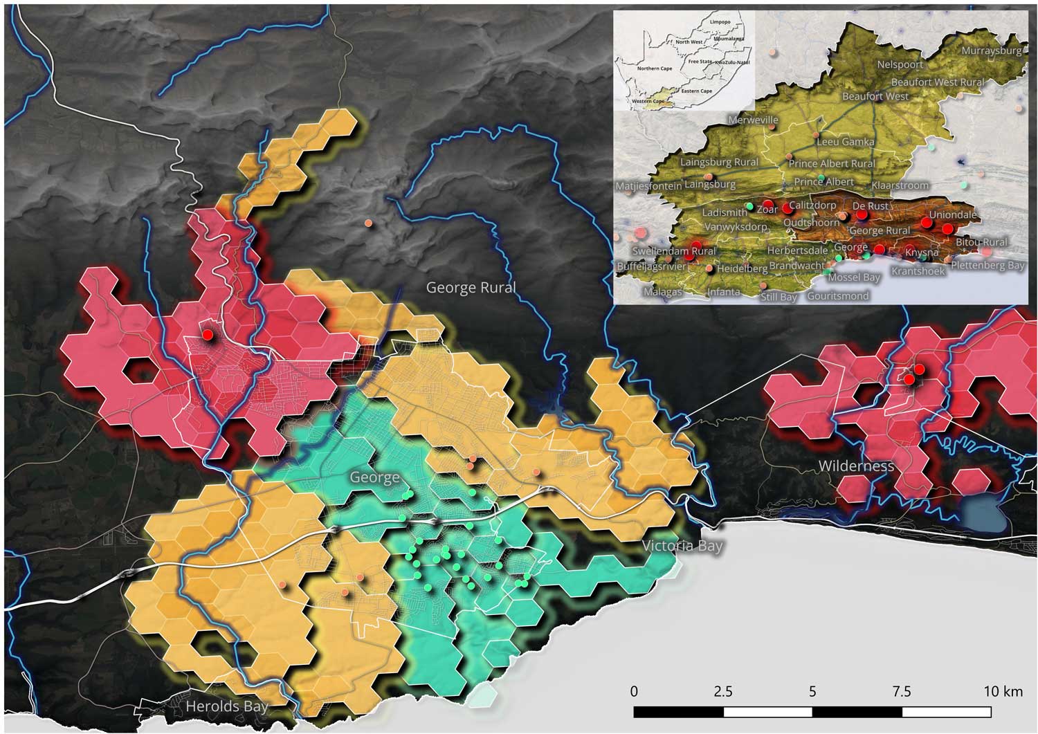
    A road network connectivity analysis prepared by AfriGIS, showing which informal settlements are hardest to reach when a river floods
    A road network connectivity analysis prepared by AfriGIS, showing which informal settlements are hardest to reach when a river floods

    AfriGIS sources exclusively from authoritative entities – never crowdsourced – and validates data against satellite imagery and even on-the-ground sources where further verification is required. The organisation holds 28 years of verified geospatial records for South Africa, which means risk profiles can be assessed not just at a point in time, but against a trackable historical baseline. For insurers recalibrating flood line assumptions after back-to-back cut-off lows, that depth of longitudinal data is a tremendous material advantage.

    For municipalities and district government, the operational argument is equally direct. Critical information about informal settlement locations, infrastructure maintenance records and access route conditions typically lives in departmental spreadsheets, separated by function.

    The Garden Route has now served as a live proof of concept – twice within a month

    When that data moves onto a shared spatial platform, electrical teams, water management and emergency services can each see where their responsibilities intersect, coordinate where necessary and act independently where possible – without duplicating effort or missing the gaps between silos. A single spatial source of truth improves decisions during a crisis, but crucially, also accelerates them at the moment when every hour counts.

    AfriGIS can integrate core data layers within hours or days of engagement. The constraint is rarely the technology.

    South Africa’s rainfall season runs through November. The ground across the Western and Eastern Cape is saturated, flood lines are being reassessed, and the 22 settlements AfriGIS identified in the Garden Route are one data point in what a national-level analysis would surface. The Garden Route has now served as a live proof of concept – twice within a month. The intelligence to act on that more broadly is available now.

    About AfriGIS
    AfriGIS is the leading geospatial information science company in Southern Africa that specialises in location-sensitive data and solutions. It provides customers across the board with a suite of web-based tools and APIs to connect to, enhance and enrich their own data with location intelligence, insights and trusted data. The organisation was founded in 1997 and celebrates more than 28 years in business. It is a level 1-certified broad-based black economic empowerment (B-BBEE) business, with more than 100 employees in Pretoria, Durban and Cape Town in South Africa, Dublin in Ireland, and Dhaka in Bangladesh.

    Stay in the loop with our latest updates and exciting news by subscribing to our newsletter, your gateway to a world of inspiration delivered directly to your inbox. Subscribe here.

    AfriGIS offers an extensive selection of premium African GIS contextual insights solutions that empower businesses to gain sharper insights into their operations, customers and markets. These contextual insights solutions, in turn, enable more intelligent decision-making, giving companies a competitive edge in their respective industries. Contact us today.

    • Read more articles by AfriGIS on TechCentral
    • This promoted content was paid for by the party concerned

    Follow TechCentral on Google News Add TechCentral as your preferred source on Google


    AfriGIS Garden Route floods Marna Roos
    WhatsApp YouTube
    Share. Facebook Twitter LinkedIn WhatsApp Telegram Email Copy Link
    Previous ArticleWhy most cloud migrations inherit risk before they create value
    Next Article Finish the job Mandela started

    Related Posts

    Finding the next Sandton - AfriGIS

    Finding the next Sandton

    3 June 2026
    The hidden risk in South Africa's payment infrastructure - AfriGIS

    The hidden risk in South Africa’s payment infrastructure

    14 April 2026
    How AfriGIS is helping retailers win the delivery race

    How AfriGIS is helping retailers win the delivery race

    4 December 2025
    Company News
    Neill Nortje appointed as country manager of Paratus Zambia

    Neill Nortje appointed as country manager of Paratus Zambia

    28 July 2026
    iONLINE launches eSim for IoT to keep device fleets connected anywhere

    iONLINE launches eSim for IoT to keep device fleets connected anywhere

    28 July 2026
    Cybercriminals are hacking trust

    Cybercriminals are hacking trust

    27 July 2026
    Opinion
    Selling vapour is corporate suicide in slow motion - Jannie van Zyl

    Selling vapour is corporate suicide in slow motion

    16 July 2026
    Brazil's online gambling crackdown is a lesson for South Africa

    How Amazon outmanoeuvred Starlink in South Africa

    15 July 2026
    The Popia problem with agentic AI - Herman Haasbroek

    The Popia problem with agentic AI

    14 July 2026

    Subscribe to Updates

    Get the best South African technology news and analysis delivered to your e-mail inbox every morning.

    Latest Posts
    Luno cutting a fifth of its workforce - South Africa not spared

    Luno cutting a fifth of its workforce – South Africa not spared

    28 July 2026
    The tech master plan for the Cape Winelands Airport

    The tech master plan for the Cape Winelands Airport

    28 July 2026
    TCS+ | A smarter approach to cloud for South African businesses - Joel Chacko and Jonathan Oaker

    TCS+ | A smarter approach to cloud for South African businesses

    28 July 2026
    Neill Nortje appointed as country manager of Paratus Zambia

    Neill Nortje appointed as country manager of Paratus Zambia

    28 July 2026
    © 2009 - 2026 NewsCentral Media
    Built and maintained by Chronon
    • Cookie policy (ZA)
    • TechCentral – privacy and Popia

    Type above and press Enter to search. Press Esc to cancel.

    Manage consent

    TechCentral uses cookies to enhance its offerings. Consenting to these technologies allows us to serve you better. Not consenting or withdrawing consent may adversely affect certain features and functions of the website.

    Functional Always active
    The technical storage or access is strictly necessary for the legitimate purpose of enabling the use of a specific service explicitly requested by the subscriber or user, or for the sole purpose of carrying out the transmission of a communication over an electronic communications network.
    Preferences
    The technical storage or access is necessary for the legitimate purpose of storing preferences that are not requested by the subscriber or user.
    Statistics
    The technical storage or access that is used exclusively for statistical purposes. The technical storage or access that is used exclusively for anonymous statistical purposes. Without a subpoena, voluntary compliance on the part of your Internet Service Provider, or additional records from a third party, information stored or retrieved for this purpose alone cannot usually be used to identify you.
    Marketing
    The technical storage or access is required to create user profiles to send advertising, or to track the user on a website or across several websites for similar marketing purposes.
    • Manage options
    • Manage services
    • Manage {vendor_count} vendors
    • Read more about these purposes
    View preferences
    • {title}
    • {title}
    • {title}