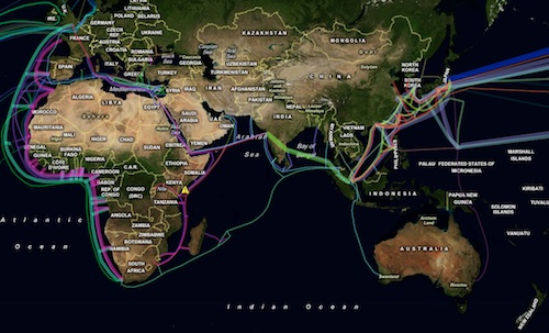
Durban-based software developer and occasional TechCentral columnist Greg Mahlknecht has built a free map showing the world’s submarine telecommunications cable systems.
The map, which took Mahlknecht several months to complete, is free of charge and will remain so. It’s available at cablemap.info.
“I saw the Telegeography map and wanted one, but found it cost US$250,” he says. “I didn’t want it that badly and looked for a free alternative to print out but couldn’t find one. I realised a free version needed to be made.”
Over time, with user contributions and guidance, Mahlknecht hopes his free cable map will eventually be more comprehensive and offer greater accuracy that the Telegeography map.
“I’m hoping someone more skilled in geographic information systems than me will see the map and offer to tidy up the routes,” he says. “The Telegeography guys clearly have someone more skilled than me drawing the cables.”
The new map clearly shows the huge volume of undersea capacity that will soon begin to serve African markets, especially along the continent’s west coast. The width of the cables on the map reflect the relative design capacities of the systems.
Mahlknecht has drawn his data from a variety of sources. “Wikipedia has a ‘submarine communications cables’ category and I used this as a starting point before going to each cable’s homepage and gathering alternative information. I have an inherent mistrust of Wikipedia data,” he says. “I had to Google a lot and augment the Wikipedia data with a lot of information found in obscure documents all over the Internet.”
The data underlying the map — Mahlknecht uses a background from Microsoft’s Bing service — will be released under the General Public Licence, the same licence that governs the release of most open-source software.
“Once the site has had some traffic and the inevitable bugs and inaccuracies have been ironed out, I’ll make the data available as a download,” he says. For now, Mahlknecht has created a feedback button and will make any proposed changes he receives manually.
Mahlknecht’s map is the second submarine cables map developed by an SA-based technologist. Steve Song, telecommunications fellow at the Shuttleworth Foundation, maintains the African undersea cables map on his Many Possibilities blog. — Duncan McLeod, TechCentral
- Subscribe to our free daily newsletter
- Follow us on Twitter or on Facebook


