SA Nokia users now have access to free real-time traffic data on their smartphones. Nokia SA has launched an update to the maps service and now offers real-time traffic conditions.
Nokia Maps comes pre-loaded on all of the Finnish manufacturer’s smartphones, and provides free turn-by-turn voice-guided navigation. The traffic service is available on all touch-based Symbian smartphones.
The announcement comes barely a week after Google launched free turn-by-turn navigation for South Africans using smartphones powered by the company’s Android operating system. Google doesn’t offer traffic information yet, but this feature is expected in coming months.
Nokia Maps traffic includes updates on congestion, road closures, road works and other traffic incidents, colour-coding roads as red, amber or green depending on traffic flow. The traffic service receives information from digital traffic sensors as well as commercial and government partners via Nokia’s subsidiary Navteq and “crowd-sourced” information from users.
Nokia says the crowd-sourcing feature means “more people that use the service, the more accurate it will get”.
Traffic information is the latest addition to Nokia Maps, which already supports drive and walk navigation, weather, social networking and location information through services such as Lonely Planet, Trip Advisor and Qype.
The company claims that Nokia Maps has the most accurate road mapping in SA, and says it includes 100% coverage of the country’s 554 239km road network, with speed limits for major roads and lane guidance for all motorways. Walk navigation is available for Cape Town and Johannesburg.
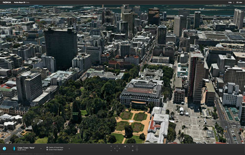
In addition to the new features for mobile devices, the browser-based Nokia Maps for desktop computers has also been updated and now includes photo-realistic 3D imaging of Cape Town. It also offers “heat mapping”, which tracks the highest density points of interest in a city.
The 3D imaging was made possible through specialised camera equipment that takes one image per second of the same object, up to 100 times, each at a different angle. The images are then joined together to form the 3D object using image processing software. — Staff reporter, TechCentral
- Subscribe to our free daily newsletter
- Follow us on Twitter or on Facebook


